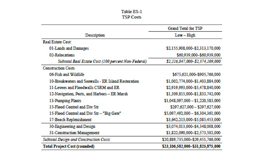
A long-awaited draft feasibility study released by the Texas General Land Office and the Army Corps of Engineers pegs the cost of constructing a series of resiliency projects along the Texas coastline at between $23 and $31 billion.
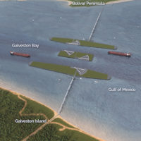
The largest project in the study is a storm surge barrier between Bolivar Peninsula and Galveston Island, known as the "Ike dike" or the "coastal spine." Other solutions include levees, floodwalls, surge barrier gates and breakwaters and natural barriers such as shoreline erosion control through marsh, beach, dune and island restoration.
The Coastal Texas Protection and Restoration Study Draft Integrated Feasibility Report and Environmental Impact Statement, released Oct. 26, is a first-of-its-kind study, according to the land office and the Corps, and has been under way since 2015. The study’s goal was to identify risk reduction solutions to address coastal storm risks to Texas’ 3,359-miles coast and determine the feasibility and impacts of building large-scale projects and ecosystem restorations. Completion of the study is the first step toward implementing the design and construction of a coastal risk management system.
“The study also includes results and lessons learned from methods used to mitigate the dangerous impacts of floods and storm surges worldwide,” said U.S. Army Corps of Engineers Galveston District Commander Col. Lars Zetterstrom in a statement.
The Oct. 26 study was released three days after President Donald Trump signed a new water infrastructure bill into law that authorized $2.2 billion in federal funds for a Corps hurricane and storm damage risk reduction project from Sabine Pass to Galveston Bay.
Eighteen coastal counties along the Texas Gulf Coast, stretching from the mouth of the Sabine River to the mouth of the Rio Grande, are included in the analysis, along with barrier islands, estuaries, coastal wetlands, rivers and streams, and adjacent areas that make up the interrelated ecosystems along the coast of Texas. The study area was divided into four sections: upper Texas coast, mid to upper Texas coast, mid Texas coast, and lower Texas coast.
The study’s “Tentatively Selected Plan” is a “Coastal Barrier Alternative,” and relies on a multiple lines of defense strategy. The plan includes a combination of structural features along the seaward portion of the study area in addition to a Galveston ring levee, a nonstructural feature on the west side of Galveston Bay, beachfill in the lower Texas coast, and ecosystem restoration along the coast.
The largest feature of the plan is a “storm surge barrier along Bolivar Roads at the Houston Ship Channel between Bolivar Peninsula and Galveston Island, which includes a floating sector gate, vertical lift gates, and a combi-wall made up of vertically driven piles with a battered support pile and a reinforced concrete cap,” according to the report.
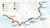
Other features of the plan include levees along Bolivar Peninsula and Galveston Island, beach and dune renourishment along the lower coast and nine landscape scale ecosystem restoration projects. Specific costs weren’t given for each project.
The study builds on the work of scientists, engineers and other experts from Rice University’s Severe Storm Prediction and Evacuation from Disasters Center, Texas A&M University Galveston and the Gulf Coast Community Protection and Recovery District.
“This coastal study is a solid step towards formalizing a regional plan. Even still, this study is in infancy stages. Communicating the benefits of this plan to communities and stakeholders is the next big step,” says Jacob Torres, project manager and senior hydrologist at Lockwood, Andrews & Newnam, who has worked with the SSPEED Center on the multiple lines of defense strategy.
What gets built will ultimately depend upon Congressional authority and funding.
Out of the total project cost estimate of $23 to $31 billion, design and construction costs alone are estimated to range from $20.89 to $29.45 billion. The study notes several measures in the plan will require cost-share with federal or state agencies. Future planning and design phases will also refine the estimated plan cost.
"I was privileged to witness first-hand the collaborative roles between USACE and coastal researchers in the sharing of approaches, methodologies, and data. More specifically, I am pleased to see the consideration of a ring levee system protecting the historical district at Galveston Island," Torres says. "The potential for backside flooding of Galveston’s historic district was revealed during Hurricane Ike and is something the SSPEED Center has studied at great length with various hurricane tracks and wind intensities. Through SSPEED’s storm surge modeling efforts, the consideration for a ring levee system was shown to be a critical component to the success of a regional storm surge mitigation plan for the upper Texas Coast."
The Corps' analysis indicated that the upper coast of Texas CSRM TSP alone could prevent an estimated $970 million to $1.288 billion in total equivalent annual hurricane/ tropical storm surge damages from 2035-2085.
A key next step will be careful planning to phase the plan such that critical components can be fast-tracked toward design and construction in order to provide the greatest amount of benefit before the next major storm, Torres says. “The TSP’s planning horizon begins in 2035. It’s quite plausible the Texas Coast will experience the next big hurricane before that time,” he says.
The report will undergo public, policy and technical review. Six public meetings will be held across the Texas coast, the first on Nov. 27 in Port Lavaca, and the last on Dec. 18 in Seabrook. The public comment period ends Jan. 9, 2019. Resource agencies, Corps and land office leadership, and external technical experts will also review the study during this time. A final report is expected in 2021.


Post a comment to this article
Report Abusive Comment