


In densely populated cities surrounded on all sides by water—the borough of Manhattan in New York City as a prime example—the risks from sea level rise and climate change are not just hypotheticals; they are existential threats.
Superstorm Sandy in October 2012 was a wakeup call, causing 44 deaths and more than $19 billion in damage in the city alone. But it was not an anomaly—extreme weather events and flash floods have only intensified since then there, and across the globe.
Remnants of Hurricane Ida in 2021 caused close to $1 billion in damage to New York City. More recently, on Sept. 29, nearly 6 in. of rain from the remnants of Tropical Storm Ophelia drenched parts of the city over a 24-hour period, causing flash floods that stranded traffic for hours and forced officials to close portions of the subway system and Terminal A at LaGuardia airport until the water receded.
Projections from the New York City Panel on Climate Change suggest the potential total loss to the city from another Sandy-type event could be astronomically higher—and that’s just the impact from extreme weather. According to the panel’s latest estimate, sea levels in the city have already risen by 1 ft since 1900 and will likely rise another 5 ft by 2100.
New York City has a plan, however. It’s now implementing a massive multibillion-dollar program to boost its resilience to climate change impacts. The initiative involves multiple projects that will provide a range of protective measures to keep residents and visitors safe and to minimize destruction from major storms.
Altogether, the projects will provide nearly six miles of flood protection using a combination of new green spaces and esplanades, some of which will extend the shoreline beyond its original edges; flood walls and gates; and stormwater improvements. The work is focused along the lower tip of Manhattan—from East 25th Street on the east side to the Brooklyn Bridge and the southernmost tip of the island, then up past Battery Park City on the west. Some floodwalls are being built underneath recreational areas, and entire sections of what is considered the current ground level in particularly low-lying areas will be elevated by several feet.
Across the Hudson River, the state of New Jersey and cities like Hoboken and Weehawken are also implementing their own multi-pronged resilience programs.

The impacts of extreme weather in September (above) and in 2012 (below), continue to disrupt life in New York City and have caused billions of dollars in damage.
Photos (above) AP Photo/Jake Offenhartz; (below) by Getty Images/CribbVisuals


The Big U and Public Engagement
The projects in Manhattan are a direct outgrowth of the “Big U” concept developed through the U.S. Department of Housing and Urban Development’s international Rebuild by Design competition launched as a response to Sandy in June 2013. The Big U was conceived by a team that included Danish firm Bjarke Ingels Group, One Architecture and consultant Arcadis, based in the Netherlands. It was envisioned as an integrated group of projects designed to meet the specific needs of the communities where they are built.
Multiple sources interviewed for this story say that lessons learned—sometimes hard ones—during the public engagement process, both during the Rebuild by Design competition and now in implementing the projects, have brought fundamental changes in how major infrastructure programs are managed.
Edgar Westerhof, an Arcadis vice president and a key team member involved in the initial Big U design, says public engagement was eye opening to both engineering firms and city administrators and planners, with long-lasting impacts on how large programs like the city resilience effort are managed.
“I think it raised our level of awareness in how to craft a participatory process with stakeholders,” says Westerhof, who also is Arcadis’ North America climate adaptation solution lead. “It sounds like a lot of kumbaya, but it’s really needed,” he explains. “It’s the only way to get accepted solutions, or solutions that are accepted by the majority.” Hundreds of meetings with key stakeholders were held in 2013 and 2014 to shape the final design, and public outreach continues to be an important function as projects move further along in construction.
Thomas Foley, commissioner of the city’s Dept. of Design and Construction (DDC), says numerous aspects of the $1.45-billion East Side Coastal Resiliency project, which began construction in 2020, were changed as a result of concerns local residents raised. Because they still wanted access to East River Park during construction, the agency split the project timeline into two phases so no more than 58% of the park would be closed at one time. That decision extended the project timeline by two years, but the tradeoff is worth it, Foley says, because it meets needs of the people who must live with the final products.
While the project will provide flood protection for 125,000 people who live in the area, most of the time it also will serve as a public amenity, with tennis courts, bike and jogging paths and other green spaces, he says. “The community uses this park and it’s critical” to get public buy-in, he adds.
Multiple Projects Will Create Integrated Line of Defense
Projects will use a variety of approaches to improve resilience to storms and sea level rise that will work collectively as a solid line of defense both in New Jersey (map 1) and lower Manhattan. These include the East Side Coastal Resiliency project along the East River in project areas 1 and 2. The completed project will elevate parts of the shoreline over floodwalls to create public amenities and parks.
*Click on the maps for greater detail
MAPS (Top LEFT and lower right) courtesy of NYC DDC; (lower left) courtesy of Rebuild by Design; Rendering (top Right) courtesy of NYC Dept of Parks and Recreation

Map 1

Area 1

Area 2

Completed Project Rendering
Making a Vision Real
Arcadis is part of the joint venture team led by AKRF/KSE that took the initial Big U concepts into final design for the project, which is expected to complete some time in 2026. HNTB/LiRo Joint Venture is providing program and construction management. Housing and Urban Development has committed more than $500 million in federal funding, and the city has committed an additional $305 million to start the first phases of the project and the Lower Manhattan Coastal Resiliency projects.
According to the DDC, the boundaries of the East Side Coastal Resiliency project correspond with the natural “pinch-points” in the 100-year floodplain: areas where the land is higher along the coastline, making it easier to close the system off from water entering from the north and south. The 2.4-mile project includes a combination of floodwalls and floodgates, elevating East River Park approximately 8 ft with flood protection beneath it and interior drainage infrastructure improvements.
State law requires the city to use a design-bid-build approach, but DDC included value engineering into contracts plus incentives for early completion, Foley says. So far, the on-time, on-schedule project has realized over $12 million in value engineering cost savings, officials say.


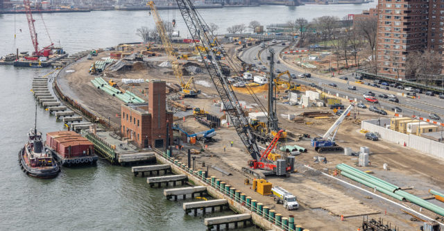
DDC manager Joseph Lione, center, on site at the East Side Coastal Resiliency Project Area 1, near East River Park, where work will continue through 2026.
Photos courtesy of NYC DDC/Matthew Lapiska
Joseph Lione, DDC associate commissioner for coastal resilience construction, points to subcontractor IPC Resilience Partners’ proposal to use precast concrete brought in on barges for an elevated esplanade, rather than mixing concrete onsite. The change not only saved the city $1.3 million, it also removed hundreds of cement trucks and other equipment vehicles from streets near the project, he says.
Foley says having the ability to use a progressive-design build approach when appropriate would create even more efficiencies and savings.
Battery Park City Authority, which is funded by the state but exempt from the project delivery rule, is using progressive design-build on the combined North-West projects, currently still in design. Its South project was too far along for the alternative delivery approach to be of use, says Gwen Dawson, a senior vice president. DDC says it is advocating for new state legislation that would permit the agency to also use progressive design-build.
Further south, DDC is also overseeing construction of the $349-million, .8-mile Brooklyn Bridge-Montgomery Coastal Resilience project located in the Two Bridges neighborhood, where 40% of residents live in public housing. It is considered part of a group of projects that comprise the Lower Manhattan Coastal Resiliency program. The city Economic Development Corp. led its design, which finished in 2021. AECOM is lead design consultant, with Jacobs providing program and construction management and J.P Picone as prime contractor.
The Brooklyn Bridge-Montgomery Coastal Resilience project team is constructing a series of deployable flip-up gates and floodwalls that most of the time will remain hidden from view, blended into public space amenities such as open-air seating and athletic event courts. During storms, however, the city will be able to flip up the gates and floodwalls to provide a barrier to storm surges and flooding. Other components of the Lower Manhattan Coastal Resiliency program are the Seaport Coastal Resilience project, the Battery Coastal Resilience project and the Battery Park City Authority projects.

The city Dept.of Design and Construction is expanding capacity in its combined sewer overflow system to reduce flooding. Above is a precast box culvert in a dewatered trench.
Photo courtesy of NYC DDC/Matthew Lapiska
Coordinating Teams
With a dizzying number of agencies, engineering and construction firms involved, coordination among teams and firms is essential, say project administrators. Rohit “Rit” Aggarwala, New York City chief climate officer and Dept. of Environmental Protection commissioner, now is staffing up the mayor’s new Office of Climate and Environmental Justice to manage coordination of the multiple projects city-wide, except the two Battery Park City resilience projects that are state-funded.
Similarly, in New Jersey, the state Dept. of Environmental Protection is implementing two winning resilience projects in the Rebuild by Design competition: RBD-Hudson River, located mainly in Hoboken, Weehawken and Jersey City, and another in the Meadowlands area that includes the towns of South Hackensack and Carlstadt. In August, the agency issued a notice to proceed to E.E. Cruz and Co., Whitestone, N.Y., on a $251-million project to build an integrated array of flood walls, gates, berms and levees to protect against storm surge.
The department completed phase one of RBD-Hudson in July 2022, a $7-million sewer separation improvement project that added additional manholes, catch basins and more than 4,000 linear ft of stormwater pipe.
The projects work synergistically, says Caleb Stratton, Hoboken’s chief resilience officer and business administrator. “There’s a symbiosis between what [the department] is building and what the city of Hoboken has built, and also what our partners at North Hudson Sewage Authority built, which are pumping stations,” he says. Taken together, the projects become a comprehensive water management strategy, which “allows us to communicate with the community and identify value and move projects forward in parallel to the larger [department] project,” Stratton adds.

Several resilience efforts include installation of flood gates, including at Project Area 2 on the East Side Coastal Resiliency project.
Photo courtesy of NYC DDC/Matthew Lapiska
There’s A Glitch
The overall efforts currently have significant public support, but when New York City bypassed public input, it faced widespread criticism. Amy Chester, managing director of Rebuild by Design, calls the city’s lack of transparency about plans to scale back features of the project due to feasibility and cost concerns under then-mayor Bill de Blasio “a mistake.”
The initial concepts had included using berms instead of flood gates and walls, plus more expansive green spaces built beyond the original edge of the island—to be first-lines-of-defense against storm surges. De Blasio announced the changes at a Friday afternoon press conference in 2018, with little explanation. “The public absolutely stood behind the project until the mayor changed it,” Chester says.
Along with vocal opposition at community board meetings following the announcement, there were in-person protests, petitions and social media campaigns, as well as legal action against the city. One of those centered around the existence and contents of a value engineering study that was the basis of the decision to forgo the previous plan.


Crews work at a floodwall being built in Project Area 1 of the ESCR project (left). Floodwall and natural plantings take shape near Stuyvesant Cove Park (right).
Photos Courtesy of NYC DDC/Mathew Lapiska
“We understood that there was supposed to be a value engineering study, and we were told there was not,” says Pat Arnow, one of the founders of East River Park Action, created in 2019 to advocate against the new East Side Coastal Resiliency plan. The group got the city to produce the report after several freedom of information requests. Chester says that if the city had agreed to provide more explanation for why it wanted to change the designs, there would have been less outrage. “It’s a hard lesson and I hope it’s a lesson that other governments learn from,” she says.
Dennis Reinknect, director of the New Jersey environmental agency’s division of resilience engineering and construction, adds that it’s important to be realistic when communicating aspects of construction that will impact residents— such as road closures and noise. “We make sure that we’re answering people’s questions quickly, before they get more upset than they probably already are,” he says. “The faster we get to answer a question or clarify [something], it really, really helps.”
Chester notes that the mix of federal, state, local and philanthropic funding has more than quadrupled since 2014 when Rebuild by Design first awarded $930 million to teams to refine their ideas. “It’s really exciting to think that the initial investment has more than quadrupled, which goes to show [not just] the size and scale of the projects, but that the main ideas of them really stuck,” she says.
But Stratton cautions: the weather can’t be controlled. When the recent rainstorms pelted the New York area, Hoboken recovered remarkably quickly, a testament to the investments the city and state have already made, he says.
Even so, Stratton emphasizes: “there’s an expectation you have to manage. It’s not about what happens; it’s about how quickly you recover.” It took two days to recover from Hurricane Ida two years ago, he points out. This year with Ophelia, it took eight hours. “Reducing the duration of a disruption is a very important measure,” he says.
Putting Climate Data to Work
The data available on climate change—how it has contributed to extreme weather events, how it may do so in the future and how and where communities may be in danger—can be found in a voluminous number of reports, analyses, maps and databases.
These include climate assessments from the Intergovernmental Panel on Climate Change; Federal Emergency Management Agency flood zone maps; and National Oceanic and Atmospheric Administration’s tracking of billion-dollar-plus climate and weather disasters. But that surplus of data can lead to a problem of excess. “Federal, state, local, tribal and territorial agencies collect and maintain a range of disaster resilience, vulnerability and loss data,” wrote Shefali Juneja Lakhina, Melanie Gall and Monica Sanders in a Federation of American Scientists post. “However, this valuable data lives on different platforms and in various formats across agency silos.”
To solve the issue, a number of organizations are taking different approaches to making data usable and useful. Brooklyn, N.Y.-based First Street Foundation has been using data—including from publicly available sources—to create readily understood representations of climate change risks, beginning with its 2020 Flood Factor tool and flood model, which combined climate change projections with information on coastal, pluvial and fluvial flooding.
The foundation has since created similar models and tools for prospective wildfire, hurricane wind and heat damage. In turn, that data, analyzed and packaged by First Street, flows back to its source. “A number of government entities are all using our data,” says Matthew Eby, founder and CEO. With Biden administration spending on infrastructure and climate resilience, Eby adds, “you need some level of data to tell you where to put that money. That’s where our data is starting to fill a void on the federal side.“
First Street has also expanded the scope of what it models, including assessing insurance risk and lost time following an event like a hurricane, taking into account real-world considerations such as availability of contractors and time needed to obtain financing and permits and review bids.
“First Street has higher resolution data” that allows for the ability to determine risk down to the property level, says Arup Principal Ibbi Almufti. The consulting firm has partnered with the foundation on several of its risk-factor models, providing loss curves for damage assessments. Arup has also used the data to inform its own in-house multihazard risk assessment platform, called Iris. “First Street brings in the hazard information, and we pair that with our vulnerability and consequence modeling,” says Almufti. “The main value we can give clients is the business case for whether to invest in resilience actions and, if so, which ones. We then can translate that into actual plans, drawings and construction documents.”
As the pace of climate change continues to shift, the models can follow suit. “We used to deliver a PDF report and that would become obsolete almost overnight because your risks are changing,” says Almufti. Now, not only can variations in external forces be tracked, “we can actually simulate implementation of risk reduction measures.”
One administration priority is making data usable for less-resourced communities. The Climate Smart Communities Initiative, announced Sept. 28, will provide $12.7 million through the Inflation Reduction Act. The four-year program is designed to match communities with climate experts to create climate resilience plans. Communities that are part of FEMA’s Community Disaster Resilience Zones will have priority.
The program is designed to use already existing climate information resources, specifically the U.S. Climate Resilience Toolkit, an initiative started in 2014 that gathers an array of resilience-related tools and information on one website for ease of discovery. The importance of adding dedicated guides to the process is underscored by the site’s tools page: It contains more than 500 listings.
By Corinne Grinapol


Post a comment to this article
Report Abusive Comment