Mapping and geomapping giant Esri acquired nFrames, a photogrammetry software company based in Stuttgart, Germany, that automates the process of creating 3D maps from photos and LiDAR data. Terms of the deal, which occurred on Sept. 9, were not disclosed.
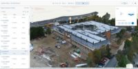
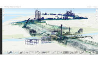
nFrame’s primary software, SURE, has an engine that creates accurate, real-world recreations in 3D from large-scale photogrammetry and LiDAR datasets. This information can then be leveraged for cities, towns and construction sites by creating meshes and overlays. SURE can also process high volumes of images.
“The work that we do is really providing core technology for getting high-fidelity, 3D reconstructions of any kind of image and laser scans,” says Conrad Wenzel, CEO and founder of nFrames.
Esri said in a statement that the acquisition will enable the fusion of imagery with 3D GIS such as its ArcGIS mapping standard. Capturing and analyzing 3D data from aerial, drone and ground-based sensors in an automated end-to-end process was another benefit that Esri touted.
Wenzel said the partnership is based on processing big data.
“Big construction sites, high-resolution data captures—we provide a core technology to turn images into useful information models on a large scale,” he said.


Post a comment to this article
Report Abusive Comment